An aerial survey conducted on Wednesday estimates that the Palisades wildfire may have destroyed over 5,300 structures in California. The conflagration, which began on January 7 in Pacific Palisades, has burned around 20,000 acres and remains zero percent contained.
The California Department of Forestry and Fire Protection used infrared technology to conduct the preliminary survey. According to an official statement, the 5,316 identified structures include “residential and commercial properties as well as smaller structures such as RVs, sheds, or other minor buildings. ”
Newsletter
Need to Know.
Your free, daily feed from The National Pulse.
Thank You!
You are now subscribed to our newsletter.
The Eaton Fire, which has burned over 10,000 acres, also remains at zero percent containment. The Hurst and Lidia Fires, which have each burned hundreds of acres, are at ten percent and 60 percent containment, respectively. The smaller Sunset Fire, which has burned approaching 50 acres, is at zero percent containment.
So far, five people have been confirmed killed in the wildfires. The immediate cause of the inferno is currently unconfirmed, but President-elect Donald J. Trump has blamed poor brush management and a failure to use water resources correctly for exacerbating the situation.
The powerful Santa Ana winds, which spread the fires rapidly, are expected to pick up strength in the coming hours, meaning the situation could worsen significantly overnight.
❓WHAT HAPPENED: Residents in central Cuba partially destroyed a local communist party headquarters during a protest over energy and food shortages.
👤WHO WAS INVOLVED: Cuban citizens, the Cuban government, and President Miguel Díaz-Canel.
Newsletter
Need to Know.
Your free, daily feed from The National Pulse.
Thank You!
You are now subscribed to our newsletter.
📍WHEN & WHERE: Saturday in Moron, a city in central Cuba.
💬KEY QUOTE: “Vandalism acts in Moron were directed at the building,” said Cuban government sources via state media.
🎯IMPACT: The incident highlights Cuba’s ongoing energy crisis, worsened by a lack of fuel shipments and U.S. sanctions.
IN FULL
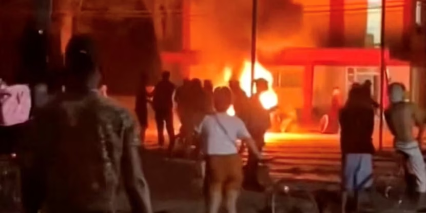
A group of residents in Moron, central Cuba, protested early Saturday, targeting the local headquarters of the ruling communist party.
The demonstration, reportedly tied to the island’s energy and food supply issues, resulted in the partial destruction of the building, and five individuals were arrested.
Cuban authorities labeled the event as “vandalism acts,” stating that protesters threw stones and set fire to furniture in the building’s reception area. Social media videos also revealed damage to a drugstore and a store in the area.
The Cuban government has opened an investigation into the incident amid the country’s ongoing severe energy shortages. President Miguel Díaz-Canel confirmed on Friday that no petroleum shipments have arrived in Cuba for three months, attributing the crisis to a U.S. energy blockade. He added that the country is currently relying on a mix of natural gas, solar power, and thermoelectric plants.
The energy crisis has forced the shutdown of two power plants and limited operations at a solar park. A recent blackout was blamed on a broken boiler at a thermoelectric plant, which caused a complete shutdown of Cuba’s power grid.
As Cuba grapples with these challenges, President Díaz-Canel noted that discussions are underway with the U.S. government, marking the first official acknowledgment of such talks amidst the ongoing crisis.
Join Pulse+ to comment below and receive exclusive email analyses.
show less
show more
By Popular Demand.
The National Pulse Now has an on-site comments section for members. Sign up today and be part of the conversation in our community of almost 15,000.
WE ARE 100% INDEPENDENT AND READER-FUNDED. FOR A GUARANTEED AD-FREE EXPERIENCE AND TO SUPPORT REAL NEWS, PLEASE SIGN UP HERE, TODAY.
❓WHAT HAPPENED: Left-libertarian comedian Bill Maher addressed the tenth anniversary of the #OscarsSoWhite campaign, declaring it is time to move on from the diversity complaints surrounding the Oscars.
👤WHO WAS INVOLVED: Bill Maher, the Academy of Motion Picture Arts and Sciences, and notable actors such as Ke Huy Quan and Zoe Saldaña.
Newsletter
Need to Know.
Your free, daily feed from The National Pulse.
Thank You!
You are now subscribed to our newsletter.
📍WHEN & WHERE: Maher’s remarks were made during his HBO show Real Time on Friday, March 13, 2026.
💬KEY QUOTE: “You couldn’t make Titanic today and hope to get nominated, or Braveheart, or Amadeus.” – Bill Maher
🎯IMPACT: Maher criticized new Academy rules for Best Picture eligibility and called for an end to ongoing complaints about the Oscars’ diversity, arguing that significant progress has already been achieved.
IN FULL
Comedian Bill Maher, during his HBO show Real Time, marked the tenth anniversary of the #OscarsSoWhite campaign by declaring that it is time to move on from the movement, as its goals have largely been achieved. Maher pointed out that eight of the last ten Best Director awards have gone to individuals from underrepresented groups and that 60 percent of honorary Oscars have also been awarded to such groups.
“Take the win,” Maher told his audience, adding, “The Oscars are no longer a long, boring show full of white people. It’s a long, boring show full of all people.” He highlighted recent diverse winners, including Ke Huy Quan for Everything Everywhere All at Once in 2023 and Zoe Saldaña for Emilia Pérez in 2025. Maher also referenced films like Moonlight, CODA, and The Shape of Water, which have won major awards in recent years.
WATCH: Lib comedian Bill Maher rips into Hollywood over diversity quotas: "You couldn't make Titanic today and hope to get nominated, or Braveheart, or Amadeus." pic.twitter.com/YToRdQYEjH
Maher criticized the Academy’s new rules for Best Picture eligibility, which require films to meet specific diversity quotas in casting and crew composition.
“You couldn’t make Titanic today and hope to get nominated, or Braveheart, or Amadeus,” he argued. He also noted that critically acclaimed films like Apollo 13 would not meet the current criteria, stating, “White people have done some stuff.”
Maher dismissed the notion that Hollywood remains biased in favor of white actors, saying, “No Academy member this year filled out their ballot thinking: ‘Well, I didn’t think Timothée Chalamet was very good, but I’ll vote for him because he’s white.'”
He also criticized the Academy for creating rules that he believes amount to “affirmative action” for films, adding, “The whole thing is so Hollywood. A room full of know-nothings who call themselves the Academy, making everyone tremble before their judgment.”
The #OscarsSoWhite campaign began in 2015 as a hashtag from April Reign, a former lawyer-turned-editor, in response to the lack of diversity among nominees. While it gained significant traction online, Maher argued that the campaign’s goals have been realized and that ongoing complaints are unwarranted. He concluded by saying, “Maybe the hashtag should be #OscarsSoWrong.”
Join Pulse+ to comment below and receive exclusive email analyses.
show less
show more
By Popular Demand.
The National Pulse Now has an on-site comments section for members. Sign up today and be part of the conversation in our community of almost 15,000.
WE ARE 100% INDEPENDENT AND READER-FUNDED. FOR A GUARANTEED AD-FREE EXPERIENCE AND TO SUPPORT REAL NEWS, PLEASE SIGN UP HERE, TODAY.
❓WHAT HAPPENED: A mass shooting at Old Dominion University (ODU) in Virginia left two people dead, including the gunman, and two others injured. The attack is being investigated as an act of terrorism.
Newsletter
Need to Know.
Your free, daily feed from The National Pulse.
Thank You!
You are now subscribed to our newsletter.
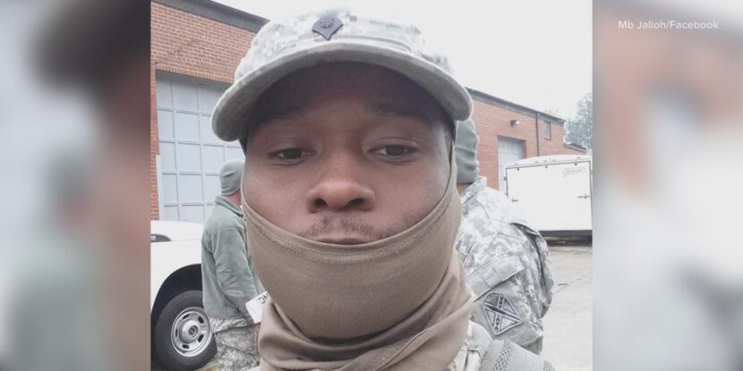
👤WHO WAS INVOLVED: Shooter Mohamed Bailor Jalloh, a former National Guardsman convicted in 2015 for supporting the Islamic State (ISIS), and Reserve Officers’ Training Corps (ROTC) students who subdued him. Victim Lieutenant Colonel Brandon Shah, a veteran Army helicopter pilot, was killed in the attack.
📍WHEN & WHERE: The shooting occurred on Thursday at Old Dominion University in Norfolk, Virginia.
💬KEY QUOTE: “This is not an ODU problem. This is a national sickness. We live in a country where people care more about guns than they care about six-year-old children.” – Norfolk Commonwealth’s Attorney Ramin Fatehi
🎯IMPACT: Norfolk Commonwealth’s Attorney Ramin Fatehi is blaming pro-gun advocates for the shooting, deflecting from the likely Islamist motivations of the shooter.
IN FULL
Norfolk Commonwealth’s Attorney Ramin Fatehi, a George Soros-backed prosecutor, is facing backlash after attributing a deadly shooting at Old Dominion University (ODU) to pro-gun advocacy rather than the attacker’s background as an Islamic State (ISIS) supporter. Speaking at a press conference, Fatehi framed the incident as part of a broader national issue. “This is not an ODU problem. This is a national sickness. We live in a country where people care more about guns than they care about six-year-old children,” he said. He also criticized lawmakers and the courts, condemning what he called “the cult of gun absolutism.”
Authorities identified the gunman as 36-year-old Mohamed Bailor Jalloh, a former Virginia National Guardsman and naturalized immigrant originally from Sierra Leone. Jalloh had previously been convicted in 2016 for attempting to provide material support to ISIS and received an 11-year federal prison sentence. However, he was released in 2024 after serving nine years.
Investigators say Jalloh opened fire during an ROTC class inside Constant Hall on ODU’s Norfolk campus. The attack left Lieutenant Colonel Brandon Shah dead. Shah, a decorated Army helicopter pilot who served in Iraq, Afghanistan, and Eastern Europe, returned to ODU in 2022 to lead the school’s military science program.
Several ROTC cadets intervened and subdued the gunman during the attack, preventing further casualties. FBI Director Kash Patel confirmed the bureau is investigating the shooting as an act of terrorism and praised the “extreme bravery and courage” of the cadets who confronted the attacker. FBI spokesman Dominique Evans also commended the students, stating, “They rendered him no longer alive. I don’t know how else to say it.”
Fatehi defended his comments, saying, “I absolutely stand by what I said. It is the truth, no matter how much the gun lobby wants to deny it.” Addressing the suspect’s extremist ties, he added that “no matter the ideology of an attacker, that attacker is more dangerous with a gun than without one.”
Fatehi’s campaign has received substantial backing from political action committees (PACs) linked to far-left billionaire George Soros, totaling more than $650,000 in support between 2021 and 2025. Soros-backed prosecutors across the United States have drawn scrutiny from critics who argue their policies prioritizeprogressive criminal-justice reforms over traditional prosecution.
Join Pulse+ to comment below, and receive exclusive e-mail analyses.
show less
show more
By Popular Demand.
The National Pulse Now has an on-site comments section for members. Sign up today and be part of the conversation in our community of almost 15,000.
WE ARE 100% INDEPENDENT AND READER-FUNDED. FOR A GUARANTEED AD-FREE EXPERIENCE AND TO SUPPORT REAL NEWS, PLEASE SIGN UP HERE, TODAY.
❓WHAT HAPPENED: The Islamic Resistance in Iraq has announced bounties for information leading to the capture or “neutralization” of high-ranking U.S. military or intelligence officials.
👤WHO WAS INVOLVED: The Islamic Resistance in Iraq, U.S. military officials, and intelligence agencies operating in Iraq.
Newsletter
Need to Know.
Your free, daily feed from The National Pulse.
Thank You!
You are now subscribed to our newsletter.
📍WHEN & WHERE: Announced via Telegram, targeting U.S. personnel in Iraq and the wider region.
💬KEY QUOTE: “This pressure affects personnel across all disciplines—whether within the U.S. military or other intelligence and espionage agencies operating in Iraq and the wider region,” the group stated.
🎯IMPACT: The bounty offer represents a significant escalation in threats against American forces and intelligence operations in the region.
IN FULL
An Iran-backed terror proxy in Iraq is offering a bounty of 150 million Iraqi dinars for information that could lead to the capture or “neutralization” of high-ranking U.S. military officials or senior intelligence leadership. The bounties issued by the Islamic Resistance in Iraq were posted on Telegram.
“In the Name of God, the Most Gracious, the Most Merciful: The tightening of the noose around American forces on the ground has led to a curtailment of their security options,” the group stated, before continuing, “This pressure affects personnel across all disciplines—whether within the U.S. military or other intelligence and espionage agencies operating in Iraq and the wider region—compelling them to relocate to alternative (civilian) sites that they perceive as more secure.”
“Accordingly, we hereby announce the allocation of a ‘substantial financial reward’ in exchange for providing information regarding these targets,” the Islamic Resistance in Iraq added.
Iranian-backed terror proxies have long targeted U.S. military and intelligence officials across the Middle East. One of the most horrifying examples of this practice was the 1985 abduction, interrogation, torture, and murder of the Central Intelligence Agency (CIA) station chief in Beirut, William Francis Buckley, by Hezbollah and its Islamic Revolutionary Guard Corps (IRGC) handlers.
Buckley was abducted by the Shia militia called Islamic Jihad—the predecessor to Hezbollah—in March 1984. He was held for an estimated 19 months before his execution. During that time, Buckley was subjected to gruesome torture, including what appears to have been the flaying of his skin while he was still alive. His body was later dumped along a road near the Beirutairport, covered in bandages and blood, while a catheter was also left embedded inside him.
Join Pulse+ to comment below, and receive exclusive e-mail analyses.
show less
show more
By Popular Demand.
The National Pulse Now has an on-site comments section for members. Sign up today and be part of the conversation in our community of almost 15,000.
WE ARE 100% INDEPENDENT AND READER-FUNDED. FOR A GUARANTEED AD-FREE EXPERIENCE AND TO SUPPORT REAL NEWS, PLEASE SIGN UP HERE, TODAY.
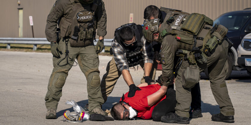
❓WHAT HAPPENED: An armed man who entered Zwink Elementary School in Klein, Texas, in tactical gear has been identified as a naturalized immigrant from Iraq.
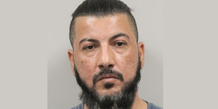
👤WHO WAS INVOLVED: Kyle Najm Chris, born Muhi Mohanad Najm, a 39-year-old resident of Klein, Texas.
Newsletter
Need to Know.
Your free, daily feed from The National Pulse.
Thank You!
You are now subscribed to our newsletter.
📍WHEN & WHERE: The incident occurred on Tuesday at Zwink Elementary School, with Najm taken into custody on Wednesday at 6:30 PM.
💬KEY QUOTE: “From the moment the individual left the front office, we were actively working with multiple law enforcement agencies to identify and apprehend this individual,” the school wrote in a message to parents.
🎯IMPACT: No students or staff were harmed. The suspect was identified using security footage and databases before being arrested.
IN FULL
An armed man who entered Zwink Elementary School in Klein, Texas, earlier this week in full tactical gear has been positively identified as Kyle Najm Chris, previously known as Muhi Mohanad Najm, an Iraqi immigrant naturalized as a U.S. citizen under the Joe Biden regime in 2022. He now faces a third-degree felony charge of possession of a prohibited weapon for carrying a firearm onto school property.
The 39-year-old allegedly walked into the school’s main office wearing a load-bearing vest with a holstered handgun and a taser. When school personnel questioned him about how he had gotten past security and asked for identification, he stated that the front door had been left unlatched. He refused to provide any personal details or justification for his presence, then left the building, entered a dark blue Dodge Charger, and drove away.
In a message to families, the district explained why no immediate public alert was issued: “Sending a public notification during that window could have… tipped off the suspect, and delayed the arrest.”
The suspect was identified through a combination of school surveillance video, facial recognitiontechnology, and vehicle license plate records. He was arrested at his residence on Wednesday at approximately 6:30 PM. Investigators have confirmed he has no connection to Klein ISD, the school, or any students or staff. Records show he holds a Texas Concealed Handgun License and a private investigator license.
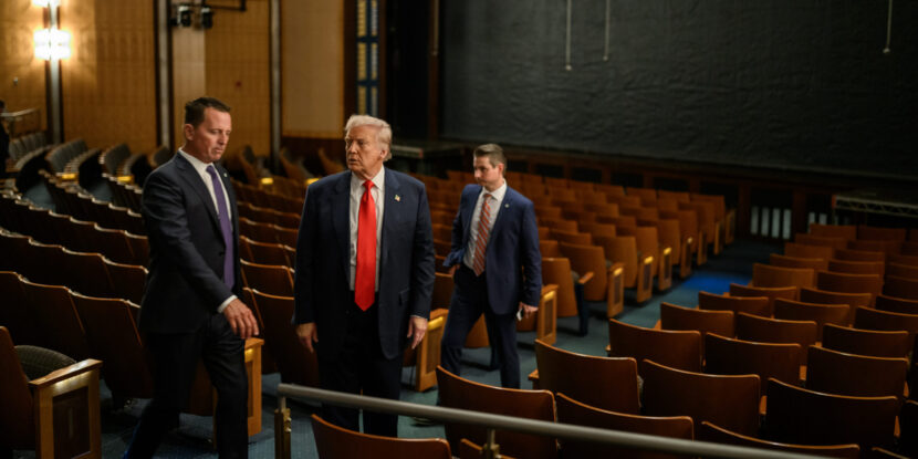
❓WHAT HAPPENED: Ambassador Richard Grenell is expected to move on from his role as head of the Kennedy Center, as the organization moves into a two-year reconstruction period.
Newsletter
Need to Know.
Your free, daily feed from The National Pulse.
Thank You!
You are now subscribed to our newsletter.
👤WHO WAS INVOLVED: President Donald Trump, Richard Grenell, and the Kennedy Center leadership.
📍WHEN & WHERE: The announcement could come as soon as today, with Grenell having served as president since February 2025.
🎯IMPACT: The move signals a shift in leadership as the Kennedy Center prepares for a two-year renovation.
IN FULL
Ambassador Richard Grenell is believed to be leaving as head of the Kennedy Center, according to sources familiar with the matter. The National Pulse has independently confirmed the reporting, which first appeared in CNN and Axios on Friday afternoon.
At the time of publication, President Trump had just issued the following Truth Social message: “Ric Grenell has done an excellent job in helping to coordinate various elements of the Center during the transition period, and I want to thank him for the outstanding work he has done.”
The move comes as the arts and culture institution, which now bears Trump’s name on its façade, is expected to close for two years for renovations. Grenell’s replacement is long-standing D.C.-area facilities manager Matt Floca. Floca has worked on D.C. area buildings projects for years, and holds a bachelor of science in construction management from Louisiana State University. He was recently appointed to the Kennedy Center management team.
Grenell will remain involved with the center in an advisory role.
Trump said of Floca, on Friday afternoon: “I am pleased to announce that Matt Floca, subject to the approval of the Board of Directors, will be named the Chief Operating Officer and Executive Director, of THE TRUMP KENNEDY CENTER where, as Vice President of Operations, Matt has helped us achieve tremendous progress in bringing the Center to the highest level of Excellence! A Complete Reconstruction of THE TRUMP KENNEDY CENTER will begin after the July 4th Celebration, with a scheduled Grand ReOpening in approximately two years.”
President Trump is believed to be a long-standing admirer of Ambassador Grenell, despite numerous establishment operations to drive a wedge between them. Grenell has recently been the target of leaked media hit pieces, believed to have come from within the RINO faction of the GOP, designed to keep him out of a new potential role. Some have suggested that Amb. Grenell would be an ideal fit to help lead the Olympic Games in Los Angeles this summer.
While leading the Kennedy Center, Grenell often bucked the trends of the far-left arts world, and helped produce some of the highlights of the last year, including the spellbinding Les Miserables run, as well as The Trump-Kennedy Center Honors.
Join Pulse+ to comment below and receive exclusive email analyses.
show less
show more
By Popular Demand.
The National Pulse Now has an on-site comments section for members. Sign up today and be part of the conversation in our community of almost 15,000.
WE ARE 100% INDEPENDENT AND READER-FUNDED. FOR A GUARANTEED AD-FREE EXPERIENCE AND TO SUPPORT REAL NEWS, PLEASE SIGN UP HERE, TODAY.
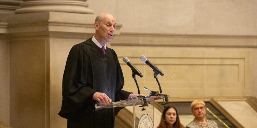
❓WHAT HAPPENED: An anti-Trump federal judge quashed grand jury subpoenas sent to the Federal Reserve Board, citing them as a pretext to pressure Chairman Jerome Powell to lower interest rates or resign.
👤WHO WAS INVOLVED: Federal Reserve Chairman Jerome Powell, U.S. Attorney Jeanine Pirro, and U.S. District Court Judge James Boasberg.
Newsletter
Need to Know.
Your free, daily feed from The National Pulse.
Thank You!
You are now subscribed to our newsletter.
📍WHEN & WHERE: The ruling was dated March 11 and unsealed on Friday in the U.S. District Court for the District of Columbia.
💬KEY QUOTE: “The Court must thus conclude that the asserted justifications for these subpoenas are mere pretexts,” wrote Chief Judge James Boasberg.
🎯IMPACT: The move by Judge Boasberg is relatively unprecedented, and U.S. Attorney for the District of Columbia Jeanine Pirro says her office will appeal the decision.
IN FULL
Anti-Trump federal judge James Boasberg has quashed grand jury subpoenas issued to the Federal Reserve Board, claiming it is his belief they were intended to pressure the central bank’s chairman, Jerome Powell, into either cutting interest rates or resigning. The move is relatively unprecedented, especially as Judge Boasberg appears to be implying the government and the grand jury itself must have probable cause to issue subpoenas. Notably, the U.S. Supreme Court has long upheld grand juries’ far-reaching investigatory powers, going so far as to hold that subpoenas can be issued even on the mere rumor of a crime.
In his ruling, Boasberg specifically argued that subpoenas were a political “pretext” to engineer an outcome desired by President Donald J. Trump and claimed there is a lack of evidence of malfeasance on Powell’s part. In January, U.S. Attorney Jeanine Pirro launched a criminal investigation into Powell, serving subpoenas related to testimony he gave to a Senate committee about renovations to the central bank’s offices. These renovations have seen cost overruns well over a billion dollars.
Boasberg wrote, “There is abundant evidence that the subpoenas’ dominant (if not sole) purpose is to harass and pressure Powell either to yield to the President or to resign and make way for a Fed Chair who will.” He added, “The Court must thus conclude that the asserted justifications for these subpoenas are mere pretexts.”
The chief judge for the United States District Court for the District of Columbia also cited President Trump’s public criticisms of Powell, including a social media post in which Trump referred to Powell as “TOO LATE, and actually, TOO ANGRY, TOO STUPID, & TOO POLITICAL, to have the job of Fed Chair.” The judge noted that such comments formed part of a pattern of pressure on Powell to lower interest rates.
Appointed to the bench by former President Barack Obama, Boasberg has drawn an unusually high number of key cases involving the Trump administration, ruling against the President every time.
Join Pulse+ to comment below, and receive exclusive e-mail analyses.
show less
show more
By Popular Demand.
The National Pulse Now has an on-site comments section for members. Sign up today and be part of the conversation in our community of almost 15,000.
WE ARE 100% INDEPENDENT AND READER-FUNDED. FOR A GUARANTEED AD-FREE EXPERIENCE AND TO SUPPORT REAL NEWS, PLEASE SIGN UP HERE, TODAY.
❓WHAT HAPPENED: A United Nations (UN) watchdog criticized the United States for alleged “grave human rights violations” tied to immigration enforcement.
Newsletter
Need to Know.
Your free, daily feed from The National Pulse.
Thank You!
You are now subscribed to our newsletter.
👤WHO WAS INVOLVED: The UN Committee on the Elimination of Racial Discrimination (CERD), President Donald J. Trump, and the American Civil Liberties Union (ACLU).
📍WHEN & WHERE: The decision was issued this week; incidents cited occurred in the United States, particularly Minnesota.
💬KEY QUOTE: “This United Nations assessment is just as useless as their broken escalator, and their extreme bias continues to prove why no one takes them seriously,” said White House spokeswoman Olivia Wales.
🎯IMPACT: The UN panel’s report reignites debate over the funding of partisan international bodies unaccountable to the public.
IN FULL
The United Nations Committee on the Elimination of Racial Discrimination (CERD) has issued a decision accusing the United States of “grave human rights violations” linked to immigration policies and rhetoric under President Donald J. Trump. The panel, composed of 18 supposed independent experts, said it was concerned about what it described as “derogatory and dehumanizing language” directed at migrants.
The report highlighted statements by President Trump and other senior officials, warning that portraying migrants as “criminals or as a burden”—which is very often true—could fuel discrimination. According to the panel, such rhetoric from high-ranking officials “may incite racial discrimination and hate crimes.”
CERD also raised concerns about enforcement practices by the U.S. Immigration and Customs Enforcement (ICE) and border agents, alleging the “systematic use of racial profiling.” It further cited reports describing “inhumane conditions” inside migrant detention facilities.
The committee focused in part on enforcement activity in Minnesota, where federal immigration agents were operating. The report referenced the deaths of anti-ICE agitators Alex Pretti and Renee Good, suggesting the incidents could amount to “gross violations of international human rights law.”
The panel also pointed to a rise in migrant detentions, noting the number in custody increased from nearly 40,000 in late 2024 to about 73,000 by early 2026. It is estimated that at least 675,000 deportations have occurred since Trump returned to office in January 2025.
The White House rejected the findings. Spokeswoman Olivia Wales said: “This United Nations assessment is just as useless as their broken escalator, and their extreme bias continues to prove why no one takes them seriously.” She added that Americans are living in a “safer, stronger country than ever before” under Trump’s leadership.
The UN has faced other controversies in recent years. The organization acknowledged that at least nine staff members of the United Nations Relief and Works Agency for Palestine Refugees in the Near East (UNRWA) participated in the October 7 terrorist attacks carried out by Hamas. Separately, critics have accused the UN of defending criminals linked to narco-terrorist drug trafficking.
Join Pulse+ to comment below, and receive exclusive e-mail analyses.
show less
show more
By Popular Demand.
The National Pulse Now has an on-site comments section for members. Sign up today and be part of the conversation in our community of almost 15,000.
WE ARE 100% INDEPENDENT AND READER-FUNDED. FOR A GUARANTEED AD-FREE EXPERIENCE AND TO SUPPORT REAL NEWS, PLEASE SIGN UP HERE, TODAY.
❓WHAT HAPPENED: Cuba’s President announced talks with the Trump administration amid a fuel crisis.
Newsletter
Need to Know.
Your free, daily feed from The National Pulse.
Thank You!
You are now subscribed to our newsletter.
👤WHO WAS INVOLVED: President Miguel Díaz-Canel of Cuba and the Trump administration.
📍WHEN & WHERE: Announcement made on Friday, March 13, 2026, in Cuba.
💬KEY QUOTE: “These talks have been aimed at finding solutions, through dialogue, to the bilateral differences between our two nations.” – Miguel Díaz-Canel
🎯IMPACT: The Cuban government faces mounting pressure as its oil supply dwindles, risking a collapse.
IN FULL
Cuban President Miguel Díaz-Canel announced Friday that his government is in discussions with the administration of President Donald J. Trump, marking the first public confirmation from Havana that talks are underway. Díaz-Canel said the dialogue seeks to address “bilateral differences” and identify “concrete actions for the benefit of the people of both countries,” but cautioned that negotiations remain in the early stages and may take time to produce results.
The talks come as Cuba faces a deepening economic and energy crisis. The island has been hit by severe fuel shortages and widespread blackouts after losing oil shipments from Venezuela, its long-time primary supplier. U.S. actions against the Venezuelan government, including the arrest of President Nicolás Maduro and restrictions on fuel shipments, effectively cut off the oil lifeline that had sustained Cuba’s power grid and transportation systems.
Without Venezuelan crude, the country has struggled to keep electricity flowing and maintain normal operations across key sectors. The shortages have disrupted public services, strained hospitals, and even affected aviation, with reports indicating the country has had difficulty securing enough fuel to refuel aircraft.
The crisis has intensified pressure on the Cuban government and sparked discussion in Washington about potential political change on the island. Some U.S. policymakers believe the loss of Venezuelan support could accelerate instability within the communist regime. President Trump has publicly suggested that the economic situation could force Havana to negotiate, saying at a recent White House event, “Cuba’s at the end of the line. They have no money. They have no oil.” He added that Cuban leaders appear eager to reach a deal.
Trump has also speculated about the long-term future of the Cuban government, recently remarking that “Cuba’s going to fall” and suggesting the United States might consider a “friendly takeover” if the regime collapses.
Analysts say any meaningful agreement between Washington and Havana would likely require significant political reforms. Among the steps often cited are the release of political prisoners, expanded civil liberties, and broader economic liberalization.
Cuban authorities have indicated they may release 51 prisoners in the near future, a move that some observers interpret as a possible goodwill gesture as the talks begin. Even so, the outcome of the negotiations remains uncertain as both governments weigh their options amid Cuba’s most severe economic crisis in decades.
❓WHAT HAPPENED: Entertainment and media company BuzzFeed—once well-known for publishing the fake Russiagate dossier on President Donald J. Trump but refocusing in recent years on online quizzes, listicles, and AI-generated pop culture content—announced late Thursday that it is facing significant debts after registering a $57 million revenue loss in 2025.
Newsletter
Need to Know.
Your free, daily feed from The National Pulse.
Thank You!
You are now subscribed to our newsletter.
👤WHO WAS INVOLVED: BuzzFeed, CFO Matt Omer, HuffPost, Tasty, and investors like Vivek Ramaswamy.
📍WHEN & WHERE: The earnings report was released on Thursday, March 12, 2026.
💬KEY QUOTE: BuzzFeed executives have “substantial doubts” as to whether the company can continue to operate—at least as it exists now.
🎯IMPACT: The company has indicated it does not currently have sufficient assets to fund its 2026 cash obligations.
IN FULL
The entertainment and media company BuzzFeed—once well-known for publishing the fake Russiagate dossier on President Donald J. Trump but refocusing in recent years on online quizzes, listicles, and AI-generated pop culture content—announced late Thursday that it is facing significant debts after registering a $57 million revenue loss in 2025. As a result of its deteriorating financial situation, BuzzFeed executives have “substantial doubts” as to whether the company can continue to operate—at least as it exists now.
Since the media company went public via an initial public offering (IPO) in 2021, BuzzFeed has struggled, like most legacy corporate media outlets, with declining readership and a lack of ad revenue. While BuzzFeed’s debt situation has improved compared to its position just three years ago—when it was $165 million in debt—the company remains in costly ownership entanglements with the far-left blog HuffPost and the social media-based food network Tasty.
“We’re exploring strategic options to complete the work we started years ago and position the Company to operate profitably on a sustainable basis,” Matt Omer, BuzzFeed’s CFO, said on its earnings statement, seemingly suggesting that the company may yet again restructure and either spin off or shutter some of its acquired properties like Huffpost. Still, such measures may not be enough, as the company has indicated it does not currently have sufficient assets to fund its 2026 cash obligations.
Notably, former Republican presidential candidate and current Ohio Republican gubernatorial candidate Vivek Ramaswamy took a 7.7 percent stake in BuzzFeed valued at approximately $6.81 million in 2024. At the time, the stock purchase made Ramaswamy the fourth-largest shareholder in BuzzFeed, behind major investors such as Comcast, NEA Management, and Hearst Communications. In a filing with the Securities and Exchange Commission (SEC), Ramaswamy indicated his intent to “engage in a dialogue with board or management about numerous operational and strategic opportunities to maximize shareholder value, including a shift in the company’s strategy.”
Despite an initial push for changes in BuzzFeed’s business model, it is unclear what interest or role Ramaswamy now has with the company.
Join Pulse+ to comment below, and receive exclusive e-mail analyses.
show less
show more
By Popular Demand.
The National Pulse Now has an on-site comments section for members. Sign up today and be part of the conversation in our community of almost 15,000.
Share Story
FacebookTwitterWhatsappTruthTelegramGettrCopy Link
Real News Fan? Show It!
Many people are shocked to learn that because of active censorship, we currently have to spend more time making sure you can even see The National Pulse, than on producing the news itself. Which sucks. Because we do this for the truth, and for you.
But the regime doesn’t want you being informed. That’s why they want us to go away. And that will happen if more people don’t sign up to support our work. It’s basic supply and demand. So demand you get to read The National Pulse, unrestricted. Sign up, today.
We don’t sell ads, and refuse corporate or political cash. It all comes down to you, the reader. I hope you can help.


.jpeg)